MAD Alternative Runs
Book

MAD Alternative Runs

Guadarrama

Hiking & trail

Ten proposals with their maps, route sheets, food and cultural add-ons.

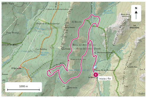
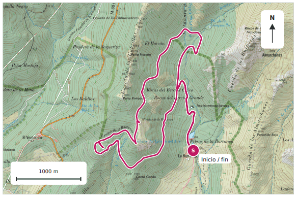
Map of La Barranca with the reference route on IGN cartography
La Barranca · reference route on IGN cartography

Five hiking routes and five trail routes. Reference itineraries to be confirmed with the guide before every outing; pending data is identified in each route sheet.

Hiking

Five complementary landscapes for private experiences: glacial cirque, granite, waterfalls, pine forest and wide views. These are catalogue base routes, not five beginner outings.

ExperienceDistanceElevation gainTime on route¹Profile / status
01 Peñalara · Laguna Grande5.6 km212 m approx.2.5-3 hUsed to walking
02 La Pedriza · El Tolmo5.8 km292 m2.5-3 hAdvanced (park)
03 Canencia · Chorrera de Mojonavalle7.6 km338 m3-3.5 hModerate; forest and waterfall
04 Fuenfría · Miradores de los Poetas9.3 km418 m3.5-4 hAdvanced (park)
05 La Barranca · Mirador de las Canchas10.3 km429 m4-4.5 hAdvanced (park)

Canencia: forest and water.

The route to the Chorrera de Mojonavalle includes a 7.6 km variant with branches, adding botanical diversity and an easy combination with food and heritage in the village.

¹ MAR times are hiking estimates with stops. They exclude transport, food and cultural visits. Distances and elevation gains refer to the reference variants in each route sheet.

The park classifies El Tolmo, the Miradores de la Fuenfría and La Barranca for advanced hikers. Snow, ice, wind or fog can change the difficulty. Elevation gains may vary between platforms depending on the model and filtering.

01

Peñalara · Laguna Grande

Total distance
5.6 km
Elevation gain
212 m approx.
Time with stops
2.5-3 h
Route type
Out and back
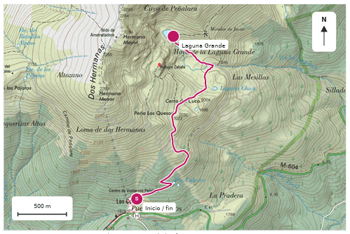
Plano de la ruta Peñalara · Laguna Grande
Base IGN · CC BY 4.0 ign.es · Magenta line: reference route.

A first immersion in the high mountains of Guadarrama. From the Cotos pass we walk among pines and landscapes shaped by ice up to the Peñalara cirque and its Laguna Grande. An experience of open views, nature and pauses to discover the mountain at another pace.

Itinerary

Peñalara Visitor Centre, in Cotos > Laguna Grande path > lagoon viewpoint > return along the same path. The published 5.6 km includes the return leg; the walk from the car park adds a few minutes.

Profile

People used to walking. Interpretive hiking takes priority, with stops to read the landscape. The route does not climb to the summit of Peñalara.

Best season

From late spring to autumn, when the path is free of snow and ice. The calendar date does not guarantee those conditions.

Where to eat

Venta Marcelino, at the Cotos pass itself. Its website states it does not take bookings: a spontaneous option for a few participants. For a day with catering arranged, an alternative with transfer to La Granja: Restaurante Puerta de la Reina, in the Parador, on request and by reservation.

Culture

Palace and gardens of La Granja de San Ildefonso, with a road transfer. Check opening times, tickets and the visit itinerary. The fountains run to their own calendar.
02

La Pedriza · El Tolmo

Total distance
5.8 km
Elevation gain
292 m
Time with stops
2.5-3 h
Route type
Out and back
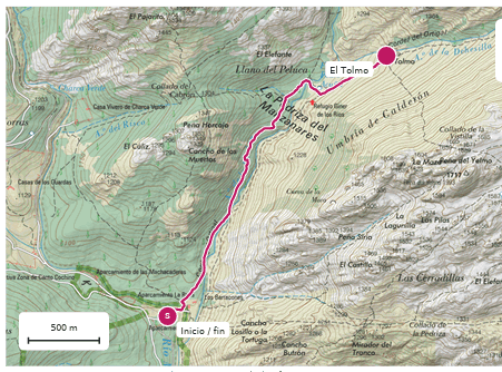
Plano de la ruta La Pedriza · El Tolmo
Base IGN · CC BY 4.0 ign.es · Magenta line: reference route.

Discover the most surprising landscape of Guadarrama among huge granite blocks, pine woods and streams. From Canto Cochino we head into La Pedriza as far as El Tolmo, a monumental rock surrounded by silhouettes that invite you to look and imagine.

Itinerary

Canto Cochino > Autopista de La Pedriza path > Prado Peluca, below the Giner de los Ríos refuge > El Tolmo > return along the same path. The proposal does not add a climb to the refuge, the Yelmo or the Collado de la Dehesilla.

Profile

People with stability and confidence on uneven rock. The park's sheet rates the walking difficulty 3 out of 5. It is presented as hiking, with time for geology and photographs.

Best season

Spring, autumn and winter days without ice or adverse weather. In summer it is best to avoid the middle of the day because of the heat.

Where to eat

Transfer from Canto Cochino to Manzanares el Real. La Charca Verde appears in the municipal directory and is an option to check the menu and group capacity.

Culture

A walk through Manzanares el Real and views of the castle from the public exterior. Check the opening status before proposing a visit inside.

03

Canencia · Chorrera de Mojonavalle

Total distance
7.6 km
Elevation gain
338 m
Time with stops
3-3.5 h
Route type
Loop with branches
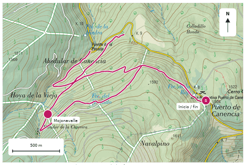
Plano de la ruta Canencia · Chorrera de Mojonavalle
Base IGN · CC BY 4.0 ign.es · Magenta line: reference route.

A forest to explore unhurried: pines, birches, yews and the sound of water. From the Canencia pass we follow the Sestil del Maillo path to the Chorrera de Mojonavalle, with stops to discover the diversity of the forest. The day can continue with mountain cooking and a walk through the heritage of Canencia.

Itinerary

Canencia pass recreation area > El Hornillo track > Chorrera de Mojonavalle viewpoint > branches of the Sestil del Maillo and the birch wood > Mirador del Norte > return to the pass. It covers the full Sierra Norte Madrid variant: 7.6 km with branches and 338 m of elevation gain.

Profile

Moderate hiking for people able to walk for about three hours through forest terrain. The group needs to handle roots, stones and damp steps; the guide confirms the route and the stream crossings.

Best season

Spring and autumn, with special interest in the water and the colour of the forest. The flow of the waterfall varies, so an abundant cascade is not guaranteed.

Where to eat

Road transfer from the pass to Canencia. Asador-restaurante Colorines for traditional cooking and roasts, on request and by reservation; the municipal directory states it opens only on Saturdays and Sundays. Alternative on other days: Cafetería Restaurante Violeta, also in Canencia.

Culture

An additional walk through Canencia and its Puente Canto, with two asymmetric arches, and the exterior of the church of Santa María del Castillo. This add-on stays in the village, requires a transfer and is not part of the 7.6 km or the hiking time.

04

Fuenfría · Miradores de los Poetas

Total distance
9.3 km
Elevation gain
418 m
Time with stops
3.5-4 h
Route type
Loop
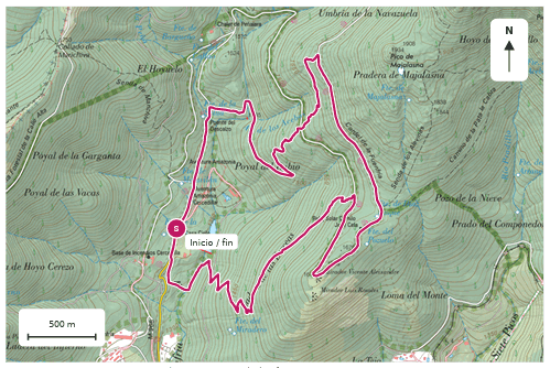
Plano de la ruta Fuenfría · Miradores de los Poetas
Base IGN · CC BY 4.0 ign.es · Magenta line: reference route.

Pine woods, historic paths and viewpoints where the mountain meets literature. We follow the Fuenfría valley up to the views of Vicente Aleixandre and Luis Rosales, with the silhouettes of Siete Picos as a backdrop.

Itinerary

Las Dehesas, next to Casa Cirilo > area around the Puente del Descalzo > climb along the valley paths > Carretera de la República and Navarrulaque meadow > Miradores de los Poetas > descent and return to the valley. As it is a loop, the guide can decide the best direction.

Profile

People able to handle about 400 m of climbing. It combines track and path, although the descents demand control. The park classifies it for advanced hikers.

Best season

Spring, summer with suitable timing and autumn. With snow or ice, it is best to review the activity and the kit.

Where to eat

Casa Cirilo, in Las Dehesas, right by the route: the combination with the least transport between the trail and the table. Its website offers online booking and states payment in cash only.

Culture

The route itself allows for reading poems and the history of hiking. As an extension in Cercedilla, the Paquito Fernández Ochoa Ski Museum, with a transfer to the village and a check of opening times for the chosen date.

05

La Barranca · Mirador de las Canchas

Total distance
10.3 km
Elevation gain
429 m
Time with stops
4-4.5 h
Route type
Loop
Plano de la ruta La Barranca · Mirador de las Canchas
Base IGN · CC BY 4.0 ign.es · Magenta line: reference route.

A grand panorama of Guadarrama without climbing its summits. From the valley of La Barranca we walk among pine woods up to the Mirador de las Canchas, facing La Maliciosa and the Guarramillas, and return along the Senda Ortiz.

Itinerary

La Barranca car park > forest track > Mirador de las Canchas > area around the old sanatorium and Mirador de La Barranca > Senda Ortiz > car park. A loop, without climbing La Maliciosa or the Bola del Mundo.

Profile

People used to walking or running in the mountains. It is a clear candidate for trail thanks to the combination of track and path. The park classifies it for advanced hikers.

Best season

Spring and autumn; summer with an early start and suitable conditions. In winter, check the snow and ice on the shaded stretches.

Where to eat

Transfer to Navacerrada. Restaurante HITA for a contemporary mountain kitchen and grills; La Petit Raclette as an alpine-style alternative with raclette and fondue. Confirm times, bookings and conditions for groups.

Culture

A walk through the centre of Navacerrada as a short extension. For a monumental visit, the Monastery of San Lorenzo de El Escorial requires a specific transfer and enough time for a full day.

Shall we plan your route?

Every outing is arranged on request, adapted to the pace, the group and the mountain conditions. Tell us what you're looking for and we'll send you a proposal.

Plan your route