MAD Alternative Runs
Book

Trail Alternative Tours

Discover the Sierra de Guadarrama National Park through trail routes designed to enjoy the environment with criteria, safety and a different outlook.

These experiences are led by an expert trail guide and designed for those looking for more than just running: nature, route, landscape and a more complete way to connect with the mountains.

In addition, the experience can close with a dining proposal at one of our partner restaurants, to turn the outing into an even more rounded plan.

Contact MAD Alternative Runs
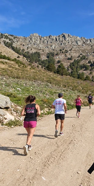
Trail runners in the Sierra de Guadarrama

Trail

Five trail routes through the Sierra de Guadarrama, from a first run through the forest to the summit of Peñalara. All of them are arranged on request and confirmed with the guide before each outing.

ExperienceDistanceElevation gainTime on route¹Profile / status
01 Angostura and Presa del Pradillo5.7 kmTo be confirmed1-1.5 hEntry level for runners with basic fitness
02 Fuenfría and Miradores de los Poetas9.3 km420 m approx.1 h 45-2 h 30Intermediate; control on descents
03 La Barranca and Mirador de las Canchas10.3 km430 m approx.1 h 45-2 h 30Intermediate
04 Camino Schmid, Puerto de la Fuenfría and Collado Ventoso12.1 km510 m approx.2-3 hIntermediate; longer duration
05 Peñalara summit via Dos Hermanas10.2 km620 m approx.2.5-3.5 hAdvanced in the mountains

¹ Our own estimates for running, walking and stops. They exclude transport, food and visits. They don't assume continuous running: slopes, uneven steps and encounters with other visitors may require walking.

Levels are a reference to be validated with the guide. The reference terrain is free of snow and ice and with suitable weather.

01

Angostura and Presa del Pradillo

Total distance
5.7 km
Elevation gain
To be confirmed
Time with stops
1-1.5 h
Route type
Loop
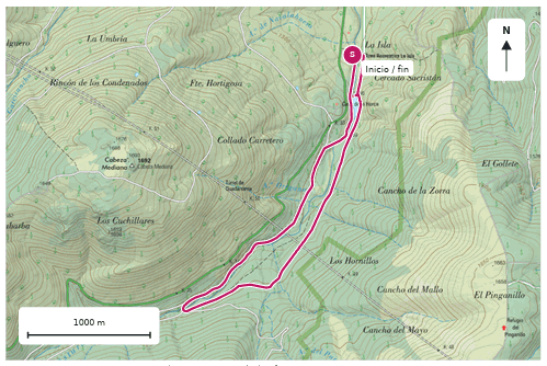
Plano de la ruta Angostura and Presa del Pradillo
Base IGN · CC BY 4.0 ign.es · Magenta line: reference route.

A first trail experience between the river Lozoya and the pine woods of the Angostura valley. A short route from La Isla to run at a comfortable pace, stop by the Presa del Pradillo dam and discover the forest without chasing a big summit.

Route

La Isla recreation area > Presa del Pradillo > stretch of the Angostura valley and the PR-M25 > loop back to La Isla, following the 5.7 km VisitMadrid route. The map corresponds to that specific variant, not to every route advertised under the name Angostura.

Why choose it

It is the entry point of the collection for clients who already run but haven't yet felt what a trail is like. The length leaves room to explain basic technique and make stops. Roots, stone and damp ground require slowing down; easy to walk does not mean you can run it without attention.

Best season

Spring and autumn; summer with suitable timing. Check ice, water flow and rain damage before every outing.

Where to eat

Restaurante La Isla, right by the start and finish. Its website states it closes on Mondays and Tuesdays; confirm the date, the table and group conditions. It is a particularly easy combination of route and meal with no transfer between the two.

Culture

Monastery of El Paular and the Carducho collection, with a road transfer and advance booking. The cultural visit is booked as an additional activity, with its own timing.
02

Fuenfría and Miradores de los Poetas

Total distance
9.3 km
Elevation gain
420 m approx.
Time with stops
1 h 45-2 h 30
Route type
Loop
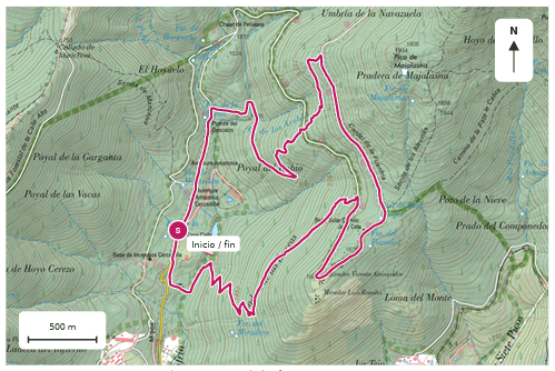
Plano de la ruta Fuenfría and Miradores de los Poetas
Base IGN · CC BY 4.0 ign.es · Magenta line: reference route.

Run through the pine woods of the Fuenfría up to the Miradores de los Poetas. A trail experience combining historic paths, views of Siete Picos and pauses to discover the relationship between the mountains and literature.

Route

Las Dehesas > area around the Puente del Descalzo > climbing paths > Carretera de la República and Navarrulaque > Miradores de los Poetas > descent to the valley. A loop. The guide decides the final direction depending on the group.

Why choose it

It alternates track and path and brings a cultural story into the activity itself. The climbs can be run or walked. The descent should not be presented as a comfortable track from start to finish: there are steep sections.

Best season

Spring, autumn and summer with suitable timing. Check especially for snow or ice on shaded slopes during the cold months.

Where to eat

Casa Cirilo, right by the route. Its website offers online booking and states payment in cash only; confirm group conditions and invoicing.

Culture

Reading poems and the history of hiking during the stops; an extension to the Paquito Fernández Ochoa Ski Museum in Cercedilla, with a transfer and a check of opening times.

03

La Barranca and Mirador de las Canchas

Total distance
10.3 km
Elevation gain
430 m approx.
Time with stops
1 h 45-2 h 30
Route type
Loop
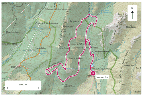
Plano de la ruta La Barranca and Mirador de las Canchas
Base IGN · CC BY 4.0 ign.es · Magenta line: reference route.

A panoramic trail facing La Maliciosa. From the valley of La Barranca we gain height among pine woods up to the Mirador de las Canchas and return along the Senda Ortiz, combining running, views and mountain paths.

Route

La Barranca car park > climbing track > Mirador de las Canchas > area around the old sanatorium > Senda Ortiz > loop back to the car park.

Why choose it

It is the most balanced option to lead the collection with: medium distance, mountain views and variety between track and path. The climb lets you manage your effort; the descent demands adapting your speed to the terrain. It does not include the summit of La Maliciosa or the Bola del Mundo.

Best season

Spring and autumn; summer early in the day. Consider ice on shaded slopes and the weather conditions.

Where to eat

Transfer to Navacerrada. Restaurante HITA for a contemporary mountain kitchen; La Petit Raclette as an alpine-style alternative. Confirm times, bookings and group conditions.

Culture

A walk through Navacerrada as a short extension. The Monastery of San Lorenzo de El Escorial fits if a longer day with a specific transfer is booked; it is not next to the end of the path.

04

Camino Schmid, Puerto de la Fuenfría and Collado Ventoso

Total distance
12.1 km
Elevation gain
510 m approx.
Time with stops
2-3 h
Route type
Partial loop
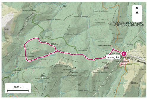
Plano de la ruta Camino Schmid, Puerto de la Fuenfría and Collado Ventoso
Base IGN · CC BY 4.0 ign.es · Magenta line: reference route.

Run one of the great classics of Guadarrama along the north face of Siete Picos. Pine woods, historic paths and the views from the Mirador de la Reina on a mountain trail experience starting and finishing at the Navacerrada pass.

Route

Navacerrada pass > Cogorros > Camino Schmid > Senda de los Cospes > Puerto de la Fuenfría > Mirador de la Reina > Collado Ventoso > Camino Schmid > back to the pass. A loop with a shared out-and-back stretch; without climbing the summits of Siete Picos.

Why choose it

It offers a longer route and a recognisable classic, with a different Fuenfría experience: it starts at the pass, at higher altitude, and follows the north face of Siete Picos. Stones, roots, steps and encounters with hikers force you to vary your pace.

Best season

Late spring to autumn, when there is no snow or ice on the path. The shaded face can keep winter conditions longer than other areas.

Where to eat

Venta Arias, at the Navacerrada pass, as a simple option near the finish; check the table and menu for the group. For a more elaborate meal you can drop down to Navacerrada or La Granja with a transfer.

Culture

Royal Glass Factory of La Granja and the Glass Technology Museum, with a transfer. It offers group visits; check whether the chosen time slot allows you to see work in the furnaces.

05

Peñalara summit via Dos Hermanas

Total distance
10.2 km
Elevation gain
620 m approx.
Time with stops
2.5-3.5 h
Route type
Out and back
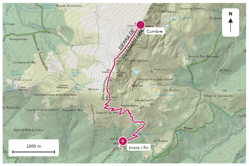
Plano de la ruta Peñalara summit via Dos Hermanas
Base IGN · CC BY 4.0 ign.es · Magenta line: reference route.

A trail challenge to the roof of Guadarrama. From Cotos we climb the zetas and Dos Hermanas to the 2,428 metres of Peñalara, combining running and walking on a high-mountain experience for experienced runners.

Route

Peñalara Visitor Centre, in Cotos > Las Zetas > Dos Hermanas > summit of Peñalara > return along the same itinerary. No crossing of the Claveles ridge and no added loop around the lagoons.

Why choose it

It is the summit proposal of the collection. It offers altitude and wide views, but it is not presented as an entry-level outing. The elevation gain, the wind and the exposure to the weather determine the difficulty more than the distance. Walking parts of the climb must be accepted; there are no shortcuts on the zetas.

Best season

Only with terrain free of snow and ice and conditions suitable for high mountains. It is not offered as an ordinary winter trail outing.

Where to eat

Venta Marcelino on returning to Cotos, bearing in mind that it does not take bookings. For a group meal booked in advance, an alternative with a transfer to La Granja and a check with the Restaurante Puerta de la Reina at the Parador.

Culture

Palace and gardens of La Granja with a transfer, its own tickets and opening times. The cultural option is booked according to the real time the mountain requires; it is not squeezed in at the cost of forcing the group's pace.

Shall we plan your route?

Every outing is arranged on request, adapted to the pace, the group and the mountain conditions. Tell us what you're looking for and we'll send you a proposal.

Plan your route